Saturday, 10 July 2010

Kashgar (China) to Naryn (Kyrgyzstan)


Due to the political instability in the south of the country, we decided to approach Kyrgyzstan via the northern Torugart pass rather than the Irkeshtam pass that heads straight to Osh.  The Torugart pass used to be infamous as one of the most difficult border crossings in Central Asia, not technically open to foreigners and requiring pre-arranged private transport on both sides of the border along with a series of permits.  These days it is expensive but seemingly hassle free.  After being confined to bed for a few days in Kashgar with gastro and fever we had enough time to find other travellers to split the costs with.  So on Monday morning we headed off in our jeep with Rachael and Tobias from Switzerland, our driver and our Chinese "guide" (an official requirement).

Finally we completed the series of Chinese checkpoints and entered the 70km or so of no-mans land before Kyrgyzstan.  The guards offered a jovial "Welcome to China!" (even though we were leaving), just metres before we were stopped by this roadblock:
Roadworks

We were told we would have to wait some hours for the roadworks on the next kilometre of new road to finish - possibly up to eight hours!  Eventually some of the cars in the queue decided to skirt the affected road by driving down a steep embankment into a floodplain and back up to rejoin the road later on.  With careful consideration and our encouragement, our driver decided to follow suit.  We negotiated the floodplain after watching the paths that other vehicles took between the maze of streams.  But our driver had trouble with the sandy path back up the hill.  With the jeep tilting at a severe and worsening angle halfway up, Luisa bolted outside the vehicle.  Roger took the steering wheel and managed to correct the path while everyone else looked on until we were back on solid ground.  At the pass itself we were handed over to our Kyrgyz driver, Aziz, who proved to be more skilled and tempered than any drivers we had come across in China.


Negotiating the floodplain

 
The Torugart Pass: entering Kyrgyzstan

The lonely Kyrgyz checkpoint at 3700m housed a few guards in a sparse, chilly room with double glazed windows wearing thick fur coats despite it being the height of summer.  They didn't give us any hassles and as we left Aziz slipped them some cigarettes.  Our first view of Kyrgyzstan was a typical scene from the north of the country.  In summer, the semi-nomadic Kyrgyz move from the towns with their animals to set up yurts in the high pastures, known as "jailoos".

 
First views of Kyrgyzstan

That night was spent at camping near Tash Rabat, a stone "caravanserai" from the 15th century that used to be an inn for silk road travellers.  It may even been a monastery in the 10th century; no one is sure.  It lies in a green valley at the end of a 10km dirt road and is built into the side of a hill.  The family in the nearby yurt unlocked it for us to explore the rooms inside.  Rachael and Tobias noticed that Kyrgyzstan, the "Switzerland of Central Asia", seems to grow more edelweiss than Switzerland itself.  We were a little underwhelmed with our first experience of edelweiss.  The views, on the other hand, were spectacular.


Luisa, Rachael and Tobias climb a hill above Tash Rabat 

From the inside

That night we were treated to the hospitality of the nearest yurt's inhabitants, who were celebrating a new baby.  There was food, Kymys (fermented horse milk), vodka and singing accompanied by a Komuz, the Kyrgyz three stringed lute.  Judging by the visitors book they may have also been celebrating their first tourists this season.  Locals had complained of a decline in tourists this year as a result of the political instability.  We gingerly sampled the Kymys and Luisa tried to find a polite way of declining too much vodka.  Kymys, we decided, tastes something like fizzy liquid blue cheese, although someone later suggested it is more akin to "vodka, as it comes back up".  In any case, it is certainly an acquired taste.  At dinner we met a French man who had lived in Kyrgyzstan for ten years running a horse tour business.  His rival is Jacqueline Ripart, a French woman who is the founder of Kyrgyz Ate (Kyrgyz Horse) and subject of a "Global Village" episode we watched back home. 

 
Pre-dinner celebrations in the yurt with kymys (foreground) and vodka

That night was the coldest night we would have in Kyrgyzstan, quite a surprise after +35 degrees Kashgar.  In the morning there was frost on the ground, ice in our water and ice in the river.  The sun quickly heated things up and we borrowed some horses for a few hours to explore the valley before driving off the Naryn.


Tash Rabat in morning light


Man practicing a Kyrgyz game: pick a coin off the ground without falling off your galloping horse

 
Luisa and fast horse

That afternoon we were dropped in Naryn where the "Community Based Tourism" operation helped us organise a two day horse trek to Lake Song Kul as well as homestay accommodation for that night, with the best shower we would have for some time.  Our plans coincided with Rachael and Tobias' so we stayed together, taking it in turns to use the kettle to boil eggs.  We were quite intrigued when our transport arrived to take us to take us there:

 
Roger helps load backpacks into Lada police car

Sunday, 4 July 2010

Xinjiang: Karakol Lake and the Karakorum Highway

We took a two day drive down the Karakorum highway to Karakol Lake with our Uighur guide, Abdul.  We stopped off at Upal village on the way for the Monday markets.

Coloured cliffs along the Karakorum Highway


 Approaching Karakol Lake

Karakol lake is an alpine lake at 3500m above sea level which is towered over by the mountain Muztagh Ata, 7546m. There are a few Kyrgyz families living in yurts where tourists also stay - ours came complete with a family and crying baby. We were fed salty yak milk tea made with lake water, presumably the cause of our next four days of fever and gastro.

Yurt, Karakol Lake and Muztagh Ata


It is a pleasant four hour walk around the lake through highland pastures past yaks, camels and the occasional motorcyclist offering a lift (for a price).

Yak


Geese

The Karakorum highway continues south, close to China's border with Tajikistan and a narrow strip of China's border with Afghanistan and towards the Khyber Pass into Pakistan.  We got as far as Tashkurgan, a Tajik town in the Tajik Autonomous County of China.  Tajiks are distinct in the language and appearance from other central asians: their language is closer to Persian rather than the Turkic languages.  Down the main street of Tashkurgan women were dressed in sequined cylindrical hats covered in scarves.


Tashkurgan

Tajik dress

On the outskirts of town is an old fortress that we could climb all over for a few yuan.  There was no information about what it is or how old, but wikipedia says it dates from the 12-1300s.


Tashkurgan Fortress


Great fortress


Luisa overlooking yurts

Tajiks, like the Kyrgyz, also live in yurts during the summer. We visited a swampy floodplain dotted with them near the fortress.  There were also also fresh water springs and, strangely, electricity and functioning lamp posts coming out of the grass.


Reflective yurt

Thursday, 1 July 2010

Xinjiang: Urumqi and Kashgar

We left Sydney on Southern China Airlines, stopping overnight in Guangzhou where we slept in the luxury 4.5 star airport hotel for the reasonable sum of US$80. From there we flew to Urumqi in China's Xinjiang province. Xinjiang is China's western-most province, north of Tibet, and has been ruled by various groups over the millenia, most recently by China. Had the Second World War played out differently, Xinjiang may have been another Soviet Stan. The traditional people are the Uighurs, a race whose appearance can vary between Indian and Chinese. Uighurs are Muslim, speak a Turkic language, and write with an Arabic script. The language is similar to Turkish but originates in Mongolia and Siberia. The Mongols spread the language through Central Asia on their way to Europe.

China has been sending ethnic Han Chinese to the region since the 1960s and they now outnumber Uighurs in Urumqi. The Han also tend to end up with the best jobs and conditions, causing resentment that resulted in the riots of 2008 and 2009. Meanwhile, the Chinese propaganda describes the region as a "brotherhood of peoples united under the great motherland." That was the English translation in the museum anyway. We had a few hours to kill in Urumqi and travelled into the city by three-wheeled motorbike and by bus.


Kashgar Old Town

A Chai hana, teahouse

From Urumqi we flew to Kashgar, 200km from China's western border. Kashgar is an oasis town on the western edge of the Taklamakan Desert. It has been a trading centre for thousands of years, being the intersection of several silk roads. Flying in, the noticeable features were the adobe (mud) houses dotting the landscape. The same material was used to build the houses in the old city, which is what attracted us to Kashgar. Unfortunately, the government has decided that the warrens of crumbling mud are unsafe and are knocking them down and moving the residents to apartments. This progress was evident from the window of our hostel, optimistically named the "Kashgar Old Town Youth Hostel". The block across the road is rubble.

Old town rubble


Traffic

A visit to the Sunday animal market brought plenty of entertainment. For reference, a sheep or goat starts around $50, a cow around $300, and a horse or camel upwards from $500.

Kashgar market arrivals

 
Outside the animal market

Manhandling the wares
 Melon transport

A Uighur market stall

Hand chiseled, double-walled copper tea cups

Cute - Muslim headwear and a tutu

Roger in old town eating a freshly baked bagel

Nan bread ready for sale


Pigeon soup row

Uighur food consists of meaty delights such as fatty kebab skewers, laghman (meat sauce with noodles that are pulled into shape by hand), bread, and the occasional salad, washed down with tea. The smell and smoke of the kebabs cooking outside every shop lets you know that you've entered a Uighur food district.

 
Streetside kebabs

Uighur style decoration

Arabic script tiles

 
Fun with signs


Luisa finds a perfect photo opportunity at Aba Hoja Tomb


Kashgar by night

The Chinese influence is also strong in the area. If you're ever there and hear an electronic "Happy Birthday" musak playing from behind you then run! A street sweeper is approaching that drives down the middle of the road blasting streams of water across both sides of the street and anything that happens to be in the way.

Most of the motorbikes are now electric, which you'd think would lower the infamous noise levels. However, they seem to make electronic noises whenever you do anything with them, and their alarms are triggered seemingly by breaths of wind.

The military and communist party presence is felt strongly, especially since the riots in 2009. All police and military are Han but Uighur "co-operators" wear red arm bands to show that they support the Chinese police in their efforts to curb violence.


  Chinese military presence in the central square

Sunday, 20 June 2010

Travelling again - Xinjiang and Kyrgyzstan


This blog has been quiet for three years because we haven't been doing any serious travelling, if you don't count our honeymoon in Vanuatu. But now we're off again. Plan A goes something like this:
  1. Fly from Sydney to Guangzhou, Urumqi, then Kashgar in western China.
  2. Spend some time with the Uighur people in the markets and hills of Xinjiang province.
  3. Travel from Kashgar to Kyrgyzstan via Irkeshtam Pass.
  4. Ride around the steppes on horses and stay in yurts.
  5. Fly out from the capital, Bishkek, back through China.
However, since we booked our tickets on the 29th of March, Kyrgyzstan has been having a few problems. A week later, on April 6, riots started in Bishkek and the president was ousted. Two months later, in early June, violence between the Kyrgyz and Uzbeks broke out in the southern city of Osh. This left hundreds dead and the city razed.

So, we're now working on plans B, C, D, E, and F:
  • Plan B is to avoid the south and cross the border via Torugart Pass, which seems to be technically illegal, but possible if you go with a tour company.
  • Plan C is to fly from China into Bishkek.
  • Plan D is Kazakhstan.
  • Plan E is Mongolia.
  • Plan F is Yunnan province in China.
This is the route we finally decided on:


View China and Kyrgyzstan 2010 in a larger map

Sunday, 16 December 2007

Peru

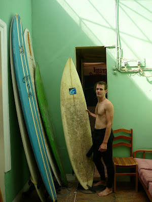
Our first encounter with Peru was the desert of the north coast. From Lima north to Ecuador the waves meet the desert dunes and nondescript dusty concrete-box towns that smell of stale urine. We passed through the towns of Piura and Chiclayo (inland) and the beach towns of Pimentel, Pacasmayo and the more gringo-friendly Huanchaco. The beaches provide good surfing at the right time of year.

Roger finds a board to hire

The mainstay of the region is fishing, which is primarily done from a type of canoe made from reeds. They are called caballitos (little horses) and the riders are skilled at negotiating the surf.

Caballitos drying in the sun

Reeds to make caballitos

Surfing caballito

Beach and desert

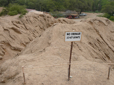
There are numerous archeological sites in the region but they have problems with grave robbers and urination.

Do not urinate on the archeological excavation site

Inca Cola, by the Coca Cola Company, is popular

From the coast we took a long bus ride into the Cordillera Blanca, the centre of the Andes. The main town, Huaraz, is a good place to spend time and numerous snowy peaks can be seen from your hotel window. We were tempted to organise a walk independently but joined a tour because it was cheap and easy.

We walked for four days through alpine grassland and small villages to Punta Union, a 4750m pass through spectacular scenery. Well, it would have been if it wasn't snowing. We did get good views on the last day of Alpamayo, once described by a famous English climber as the most beautiful mountain in the world.

Punta Union, 4750m, no views today

A blue lake

Alpamayo, the most beautiful mountain in the world

Donkeys, kind enough to carry our packs

It was now time to think about going home. Roger developed a stomach bug on the walk which was to last almost two weeks. This made bus travel unpleasant but possible with Imodium. We spent a day getting to Lima and then flew to Santiago in Chile.

Santiago is a lovely city, similar to Sydney in many ways. It has an outdoor cafe lifestyle and a climate to match. It probably deserves its own blog entry but we didn't spend enough time there to do it justice. Maybe next time...

We're now back in Australia, looking for jobs and somewhere to live.